Danube riverside cycling: the Bratislava to Devín bike route
Can you cycle from Bratislava to Devín along the Danube?
Yes — a dedicated cycling path follows the Danube's north bank from Bratislava's Old Town to Devín Castle, 14 km one-way. The flat route takes 45–60 minutes and is suitable for all fitness levels.
A European cycling route through your front door
Bratislava sits on one of the great cycling routes of Europe. EuroVelo 6 — the Atlantic to Black Sea corridor — passes directly through the city along the Danube bank, and the infrastructure that this designation has brought means that the path west toward Devín Castle is well-surfaced, clearly signed, and followed by cyclists from across the continent. What that means for a visitor is simple: you can pick up a bike near Old Town, join the river path, and reach one of Slovakia’s most dramatic castle ruins in under an hour, on a flat route that requires no special fitness or preparation.
The 14-kilometre route from Bratislava’s centre to Devín is the most popular cycling excursion from the city. It combines easy riverside riding through floodplain forest with a genuine historic endpoint — the ruined castle at the confluence of the Danube and Morava rivers, once a frontier fortress of the Great Moravian Empire, now a romantic ruin with views into three countries. This guide covers the route in detail, including bike hire, kilometre-by-kilometre conditions, what to do at Devín, return options, and variations for those who want to ride further.
GetYourGuideBratislava riverside, castle or complete city segway tourCheck availability →EuroVelo 6: what it means in practice
EuroVelo is a network of long-distance cycling routes across Europe, coordinated by the European Cyclists’ Federation. Route 6 runs 3,653 kilometres from Saint-Nazaire on the Atlantic coast of France to Constanța on the Black Sea in Romania, following the Loire, Rhine, and Danube valleys.
The Bratislava section benefits from being on a high-priority European corridor. The path is properly surfaced — largely asphalt or compact gravel — rather than the informal dirt tracks that cycling routes sometimes amount to in practice. EuroVelo 6 signage appears at regular intervals: blue signs with the yellow route number and a bicycle symbol. Combined with the Mapy.cz app (which maps the route in full and works offline), navigation is straightforward.
The route also means that the path is used by serious long-distance cyclists touring through Central Europe. On summer weekends, you will share the river bank with loaded touring bikes from Germany, the Netherlands, and beyond. This gives the route a lively, international atmosphere and is a reminder that Bratislava is not just a city on the Danube — it is a waypoint on one of the continent’s most celebrated cycling journeys.
Bike rental in Bratislava
Rekola shared bikes
Rekola operates a docking-station bike hire scheme in Bratislava using its distinctive pink bicycles. Stations are located across the city centre, including near the SNP Bridge (Most SNP) area where the riverside route begins. The Rekola app (available for iOS and Android) shows station locations and available bikes in real time. Registration requires a payment card, and hire is charged by the minute or in packages.
Rekola bikes are adequate for the flat riverside route to Devín — they are heavier than dedicated touring bikes, but on a flat path this makes little practical difference. The main limitation is return logistics: you need to dock the bike at a Rekola station, and there is no station at Devín itself. This means Rekola works better as a way to reach the start of the route from your accommodation than as your primary hire option for the full round trip.
Private hire shops
Several bike hire shops near Old Town and the riverside offer standard daily or half-day hire. Expect to pay around €15–20 per day for a standard hybrid or city bike, with electric bikes typically in the €25–35 range. Hire shops allow you to ride to Devín and bring the bike back without worrying about docking stations.
Electric bikes are worth considering if you plan to extend the ride beyond Devín, combine cycling with a long visit to the castle, or are travelling with children on standard bikes and want to be able to keep pace comfortably. The route to Devín is flat enough that an e-bike provides minimal advantage on this specific stretch, but the return journey (into a headwind, which is common on the Danube corridor) becomes noticeably easier.
Ask your hire shop about locks — most provide one but it is worth confirming. A good lock is essential if you are leaving bikes outside the castle while visiting inside.
Children and family options
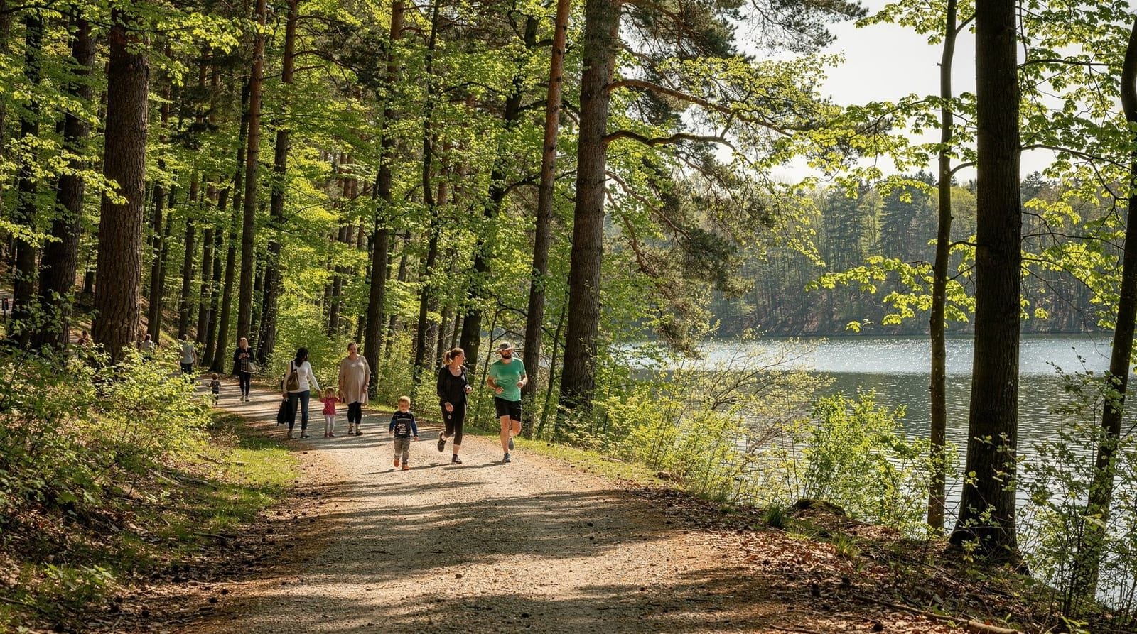
Hire shops can usually supply children’s bikes and child seats. Cargo bikes and tag-alongs (trailers that attach to an adult bike and allow a child to pedal along) are available from some providers. Call ahead if you need specific family equipment. The flat riverside path is genuinely appropriate for children who can ride confidently — there are no hills and minimal road crossings.
The route: kilometre by kilometre
Starting point: SNP Bridge and the riverside promenade
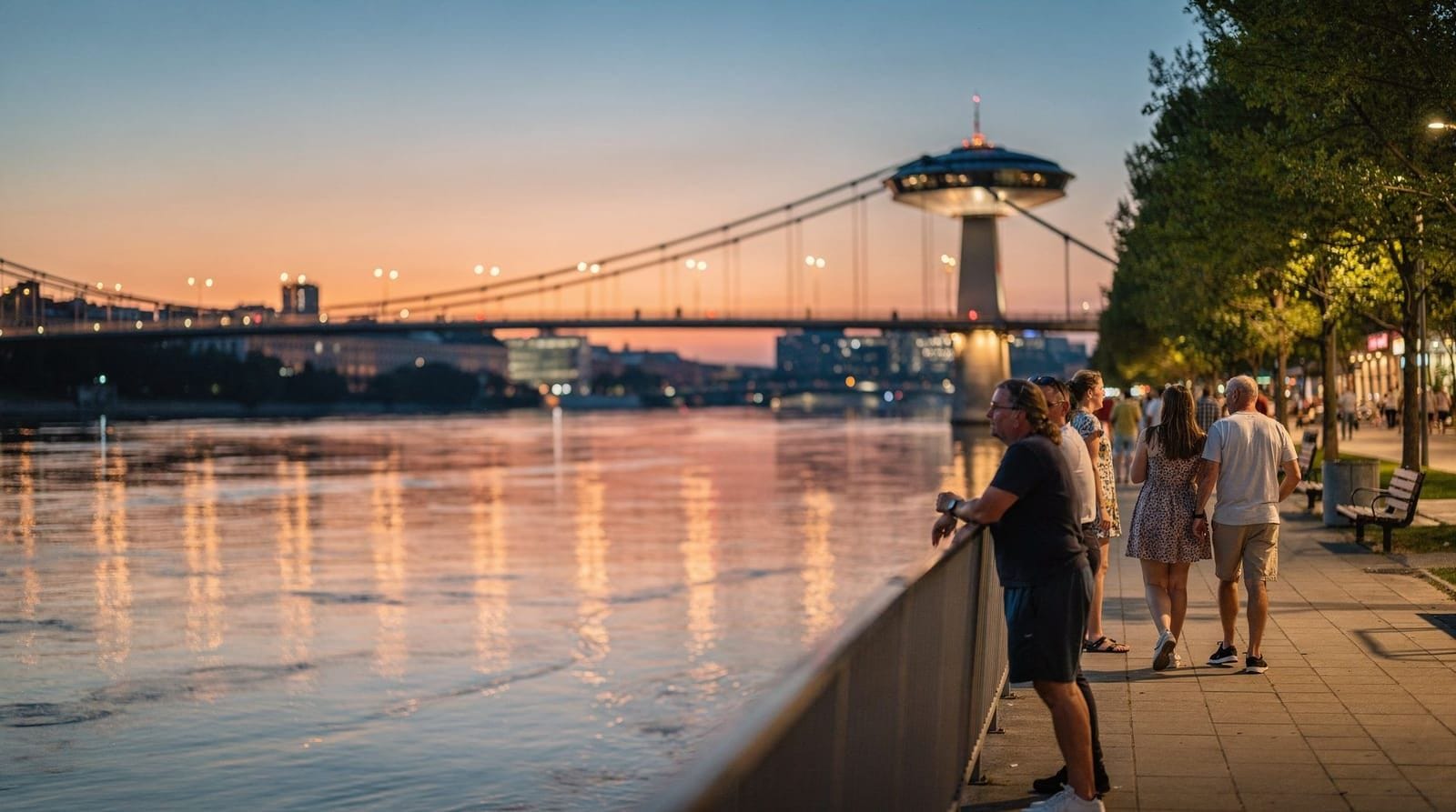
The route begins at the Most SNP (Bridge of the Slovak National Uprising) — the UFO-shaped flying saucer bridge that has become one of Bratislava’s defining landmarks. This is the natural meeting point between the Old Town and the Danube embankment, and the river path west begins on the north bank here.
From the bridge, a riverside promenade heads west. In the first section you pass the open embankment area below Old Town, with views across the river toward the Petržalka district on the south bank. This is a busy area on weekends — pedestrians, runners, and cyclists share the space — so keep your speed reasonable and be aware of people stopping to take photographs.
0–3 km: embankment and first bridges
Continuing west from the SNP Bridge, you pass under the D2 motorway bridge — a functional concrete structure that contrasts sharply with the UFO bridge you started from. Beyond it, the path moves away from the built embankment and the urban density begins to thin. Flood protection embankments rise on the landward side, planted with grass and willows.
The path surface through this section is good — asphalt or concrete — and the route is clear. A few access roads cross the cycling path; give way and pass carefully at these points.
3–6 km: floodplain forest and Austrian views
By the 3-kilometre mark, the character of the route changes noticeably. The city drops away and the path enters a section of floodplain forest — willow and poplar thickets, reed beds near the water’s edge, and a general sense of leaving the urban world behind. This section is one of the quietest and most pleasant parts of the route.
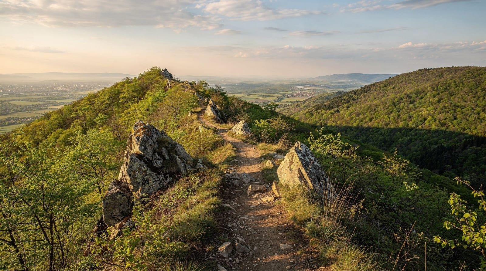
On the left (north) bank as you ride west, the slopes of Devínska Kobyla begin to rise — a nature reserve forming the southernmost promontory of the Small Carpathians. Its steep wooded hillsides are visible above the tree line and the contrast between the flat river plain and the sudden rise of the hills creates a distinctive landscape.
Looking south across the river on a clear day, you can see Austrian territory — the villages of Kittsee and Wolfsthal are on the opposite bank in Burgenland. The border here is real but invisible; the Danube corridor is a continuous ecosystem on both sides.
6–10 km: approaching Devín and the Morava confluence
The approach to Devín brings the most varied birdlife on the route. The confluence of the Morava river with the Danube is a protected wetland area and a significant site for migratory birds. Grey herons stand motionless in the shallows. Cormorants dry their wings on exposed branches. Kingfishers — brilliantly coloured and very fast — flash along the water’s edge. In spring and autumn, migratory ducks and waders use the wetlands.
The Morava itself was the Iron Curtain border between Czechoslovakia and Austria for four decades. The confluence area is now a quiet, wildlife-rich zone, but its recent history gives it a particular resonance. Our guide to communist and Iron Curtain history covers this context in depth.
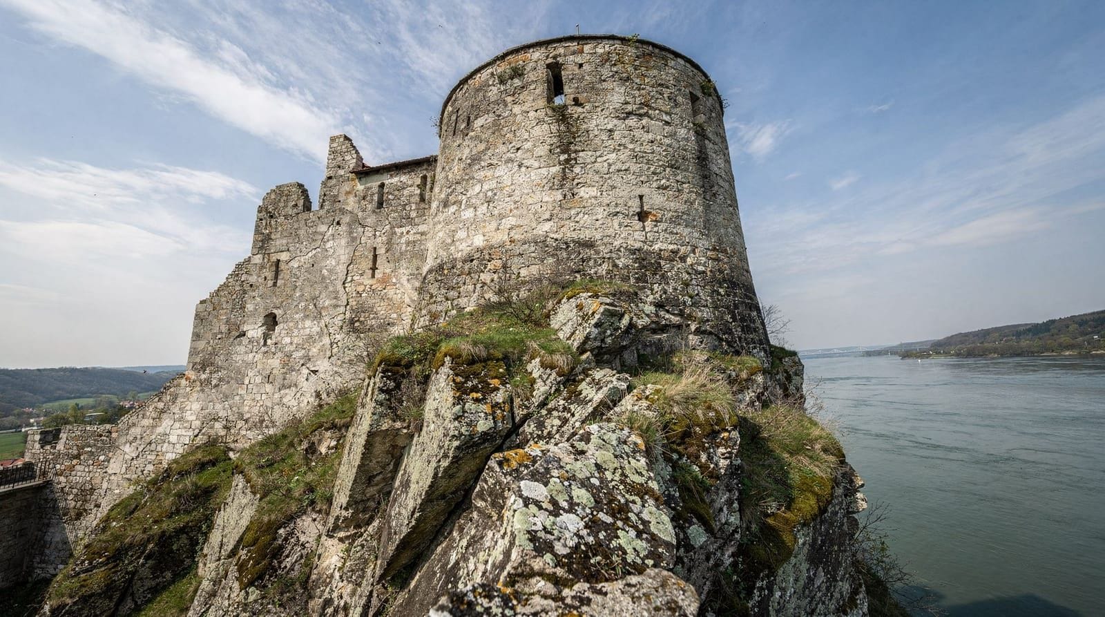
As you approach Devín village, the path becomes slightly more defined and signed. The ruined castle becomes visible on its cliff above the river long before you reach it — the dramatic silhouette of the tower against the sky is a reliable landmark.
10–14 km: Devín village and the castle
The final section brings you into Devín village — a quiet residential area that predates its absorption into Bratislava as a district. The village has a small selection of restaurants and cafés, most catering to cyclists and walkers arriving from the city. This is a good place to stop for lunch or a cold drink before or after the castle visit.
The castle entrance is a short climb from the village — there are steps and a path leading up to the ticket office. Bikes can be locked at the base of the hill. The climb takes about ten minutes on foot.
GetYourGuideBratislava cruise — Devín Castle round tripCheck availability →What to do at Devín
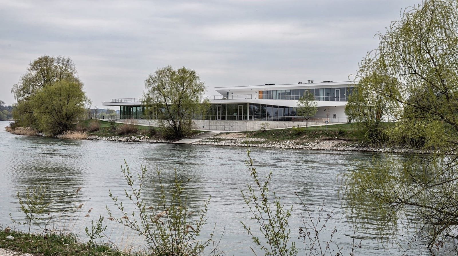
Devín Castle is one of the most evocative ruins in Slovakia. The site was occupied from prehistory through the Roman period, became a major fortress of the Great Moravian Empire in the ninth century, was used as a border castle by Hungarian kings in the medieval period, and was demolished by Napoleon’s forces in 1809. What remains is a picturesque complex of walls, towers, and cliff-edge ramparts with extraordinary views.
The museum inside covers the full archaeological and historical story well. The maiden tower at the highest point of the cliff is the most photographed element — a solitary round tower perched on a sheer rock face above the river. The views from the top of the ruins take in the Danube-Morava confluence, the Austrian bank, and the Small Carpathians ridge behind.
Allow one to two hours for a thorough visit. For a full guide to the castle, its history, and practical details, see our Devín Castle guide.
Return options
Cycle back
The most straightforward return is the way you came. With 14 kilometres of flat path, the return journey takes roughly the same time as the outward leg — 45 to 60 minutes for most cyclists. A westerly wind is common in this section of the Danube valley, which can mean that you ride into the wind on the way back (depending on conditions). Factor in slightly more time if this is the case.
Bus 29
Bus 29 runs between Devín village and the city centre. The journey takes around 30–40 minutes. Slovak city buses do not officially allow bicycles on board, which means the bus is most useful as a contingency if someone in your group has a mechanical problem or is too tired to ride back — the ride can be sorted by taxi or one person returns by bus while the bikes are ridden back.
Taxi or rideshare
A taxi from Devín back to Old Town is a practical option if you are short on time or prefer not to make the return journey. The distance is 12–15 kilometres by road and the fare is reasonable. Book through the Bolt or Hopin apps which operate in Bratislava.
Extending the ride: further options
Toward Austria and Hainburg
The Devín area sits at the Slovak-Austrian border, and the broader EuroVelo 6 route continues west into Austria toward Hainburg an der Donau. Hainburg is itself a historic walled town with castle ruins on the hill above — a rewarding extension for cyclists who want to cross into Austria. The border crossing here is open and requires no special documentation for EU citizens; visitors from outside the EU should carry their passport.
The cycling distance from Devín to Hainburg is approximately 8 kilometres. Combining the Bratislava–Devín–Hainburg route gives a total of around 22 kilometres from the city centre — a satisfying full-morning ride.
Toward Čunovo and Danubiana
From the SNP Bridge, the EuroVelo 6 route also runs east and southeast along the Danube — a completely different direction from the Devín route. Following this path leads eventually to Čunovo and the Danubiana Meulensteen Art Museum, a remarkable contemporary art museum built on a peninsula jutting into the Danube reservoir. The distance from the SNP Bridge to Danubiana is approximately 18 kilometres, mostly on dedicated cycling infrastructure.
This is a longer and more varied route, passing through the Petržalka riverside and then into open farmland and wetland. For more on this destination, see our guide to Danubiana Čunovo.
GetYourGuideBratislava riverside, castle or complete e-scooter tourCheck availability →Seasonal notes
Spring (March–May)
Spring can bring high water on the Danube. Snowmelt from the Alps causes the river to rise between February and April, and in some years the riverside path floods for short sections. Check conditions locally before setting out in March or early April. By May, conditions are usually excellent: the floodplain forest comes into leaf, the birdlife is at its most active, and temperatures are comfortable for cycling.
Summer (June–August)
Summer is the peak season for this route and for good reason — long days, reliable weather, and the river at its most inviting. Bring water; shade is limited in several sections and the path can be warm in full sun. Set out in the morning if possible to avoid the hottest part of the afternoon. Weekend mornings in July and August can be busy near the city end of the path; the route quietens considerably after the first 3 kilometres.
Autumn (September–November)
Autumn is arguably the most atmospheric season. The floodplain willows and poplars turn yellow and gold, the bird migration through the Danube-Morava confluence is at its peak, and the crowd levels drop from summer highs. Temperatures remain pleasant for cycling well into October. This season pairs particularly well with a visit to the nearby Small Carpathians wine region — you can cycle to Devín in the morning and take a bus to a wine village in the afternoon.
Winter (December–February)
The path is rideable in winter when there is no ice or snow. Some sections near the river can be icy after frost, particularly in shaded areas under trees. On clear winter days, the light on the Danube is exceptional and Devín Castle is dramatically atmospheric with low-angled winter sun. Dress warmly — the river corridor is exposed and the wind chill is significant.
Safety and practical notes
Path surface: The path is predominantly asphalt or compacted gravel. Surface quality is generally good but a few sections have tree roots causing minor undulations. Hybrid or mountain bike tyres handle the route comfortably; road bike tyres are fine on the main asphalt sections.
Road crossings: There are a few points where the cycle path crosses access roads. At each crossing, treat it as a give-way situation and look for motor vehicles, which occasionally use the embankment access roads for maintenance and delivery.
Lighting: If you are returning after dark — possible in summer if you lose track of time at Devín — a front and rear light is important. The path has no street lighting beyond the city sections.
Lock: A substantial lock is worth bringing. Devín Castle does not have secure bike storage, and you will need to leave your bike outside for the duration of your castle visit.
Water: There are no reliable water sources between the city outskirts and Devín village. Carry enough for the full journey, accounting for a warm day. The cafés in Devín village are a reliable refill point on the return.
Dogs: Dogs on leads are common on this path. Cyclists and dog walkers generally coexist without difficulty, but ring your bell or call out as you approach from behind.
Frequently asked questions about Danube cycling in Bratislava
How long does it take to cycle from Bratislava to Devín Castle?
The 14-kilometre route takes most cyclists 45 to 60 minutes at a comfortable pace. Add time for stops, photography, and navigating through the busier city-end sections. Budget two hours for the outward journey if you want to take it leisurely.
Do I need my own bike, or can I hire one in Bratislava?
Hire is easy in Bratislava. Private hire shops near Old Town charge around €15–20 per day for a standard bike and €25–35 for an electric option. The Rekola shared bike scheme also has stations near the riverside start point. For a full round trip to Devín, a private hire shop is more convenient than shared bikes, which require you to dock at a station.
Is the route suitable for children?
Yes — the flat, traffic-free path is one of the most family-friendly cycling routes in the region. Children who can ride independently (typically from around age 7–8) will manage the route well. Child seats and tag-alongs are available from hire shops (call ahead to confirm availability). The only part requiring care is the few road crossings in the city section at the start.
Can I take the bus back instead of cycling both ways?
Bus 29 connects Devín village with the city centre, but Slovak city buses do not carry bicycles. If you hire a bike, you need to return it by cycling back or arranging a taxi. One option is to hire bikes one-way and pay a small supplement for taxi return of the bikes — discuss this with your hire shop before setting out.
Is the cycling path the same as EuroVelo 6?
Yes — the route to Devín follows EuroVelo 6, the Atlantic-to-Black-Sea long-distance cycling corridor. This means the infrastructure is well-maintained and clearly signed. You may share the path with long-distance tourers who are cycling the full route through Central Europe.
What is there to eat and drink along the route?
In Devín village there are several cafés and restaurants, most open daily in the warmer months. Along the route itself between the city and Devín, there are no food or drink stops — bring snacks and water for the journey. On summer weekends, occasional vendors sometimes set up near the embankment in the city section.
For more on what to see and do once you reach Devín, the Devín Castle guide covers the history, museum, and practical visiting information in full. If you want to combine a cycling day with an evening on the water, the Danube cruises overview explains the boat options departing from Bratislava’s passenger terminal.
tours.river-cruise
Verified deep-linked GetYourGuide tours. Book through these links and we earn a small commission at no cost to you.